Map Links & Cue Sheets
GPS Navigation For the Trail
XNHAT Pro Tip: Be Prepared!
We highly recommend downloading the RideWithGPS maps, carrying the fold-out map and having the cue sheet along for the ride, too. There are only a few signs along the way that we are allowed to post (at present).
A BENEFIT FOR RideWithGPS xNHAT map users!
YOU don't have pay for membership in RideWithGPS to get all of the fancy amenities available to the paid members––
––Because we paid for you!!
Because the xNHAT upgraded to a "TOURISM" category membership, you can download our maps from the links below and automatically get all of the paid member perks!
Download the app for free!


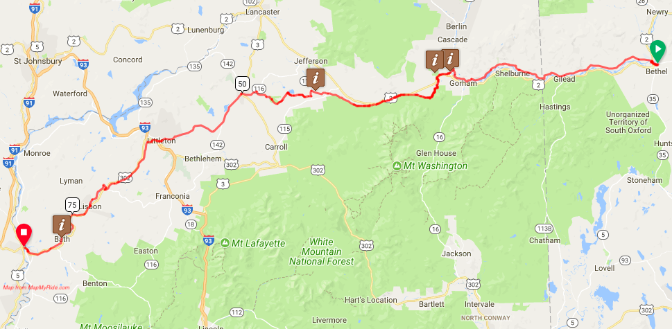
MAPS on RideWithGPS:
Click on the buttons below for the entire 83 mile EASTWARD and WESTWARD RideWithGPS maps (updated January, 2023):
The reason for the update in 2023 was to include the new section (4.4 miles) of the Ammonoosuc Rail Trail from Industrial Park Road in Littleton to Oxbow Drive in Bethlehem. We fixed a few cues for some clarification, too. Businesses come and go, so we tried to update the amenities.
Below are pdfs of Cue Sheets from RideWithGPS that you can Download and Print:
Cue Sheet of the Entire 83 mile route, EASTWARD from Woodsville, NH to Bethel, ME:
Cue Sheet of the Entire 83 mile route, WESTWARD from Bethel, Maine to Woodsville, NH
Scenic, Alternate Routes
Woodsville to Bath
There is a scenic, alternate on-road route that goes from WOODSVILLE to BATH. If you are experienced with hilly dirt road riding, try this route as an alternative to the rail trail - a pleasant ride on a scenic mostly dirt road.
There are hills, but it is an enjoyable for the views and the quiet. If you are doing an out/back, perhaps use it to go east from Woodsville to Bath. Then on your way back, ride the rail trail all the way.
Bath to Lisbon
There is another scenic alternate all paved hilly road route that goes from BATH to LISBON. Try this route on a paved road as an alternative to the rail trail. There is a climb at first, but it is an enjoyable ride with a fun downhill!
If you are doing an out/back, perhaps use it to go east from Bath to Lisbon, then on your way back, ride the rail trail all the way.
Additional Extensions & Connections
Woodsville to the Crazy Horse Campground in Littleton
For campers who would like to camp in the Littleton area, the Crazy Horse Campground is a nice place to stay. If is about 5.4 miles off the xNHAT route and includes some hills to get there. Get your food in Lisbon (Lisbon Market) or Littleton (Porfidos) on the way.
Connection to the Lamoille Valley Rail Trail
Here is an On-Road RideWithGPS connection between the xNHAT and Vermont's 93 mile Lamoille Valley Rail Trail. This connector is mostly on paved roads with some dirt roads, too. It is about 22.5 miles from Woodsville to St. Johnsbury.
Extension Eastward to Lewiston, Maine and the East Coast Greenway
For those of you who want to keep going eastward to connect with the East Coast Greenway, here is a way to get there. It is mostly on road, but good backroads . Yes, it's hilly, but what goes up provides a nice down! The route goes though Norway which is a great spot for food and lodging. Buckfield is small but might have a store open these days. The route will take you to Auburn (lodgings, food) where you will connect to a riverside bike path and then cross the river on a magnificent railroad trestle into Lewiston. Within a block or 2 you will be at Chestnut Street where you will be on the East Coast Greenway. Go north to Canada or south to Key West!
For the NH Rail Trails Tour: Here are your daily RIdeWithGPS Maps: