CROSS NEW HAMPSHIRE ADVENTURE TRAIL
  • Home
  • Maps
    • Paper Maps and pdfs
    • GPS Map Links and Cue Sheets
    • WINTER Route Border to Border
    • Day Trips on the xNHAT
    • Additional Rides Close to the xNHAT
    • Cross Vermont Trail
    • Story Map: "xNHAT, What's That?"
    • Interesting Info Links
  • Plan a Trip
    • Plan a Trip
    • Trail Conditions Update
    • What is the Surface Like?
    • What Bicycle to Ride?
    • What About Food?
    • Where to Stay?
    • Is There a Bike Shop?
    • What about Bike Rentals?
    • Parking: Day and Multi Day
    • Shuttle Services
  • DONATE
    • DONATE
    • More Ways to Support Us
  • North Country Welcomes Bicyclists
  • North Country Tri-Town Bike Friendly Initiative
  • Photos
    • Photo Tour of the Trail
    • Four Seasons on the Trail
  • News and Events
    • What's a Beaver Deceiver?
    • "Wheel Life" NH Magazine Cover Story August 2020
    • Israel River Bridge Restoration
    • Winter Explorations of the Rail Trails
  • Contact

​The Cross New Hampshire Adventure Trail

​
​

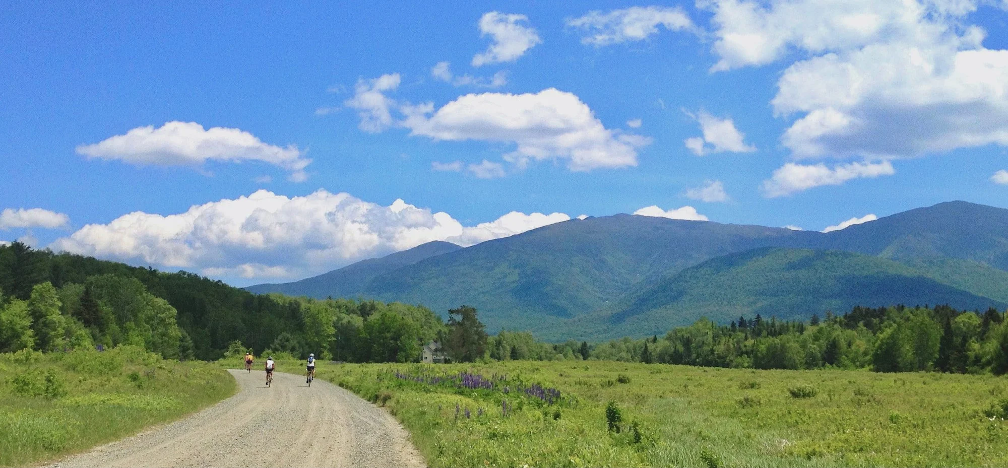
Travel 83 Miles Across Northern New Hampshire 

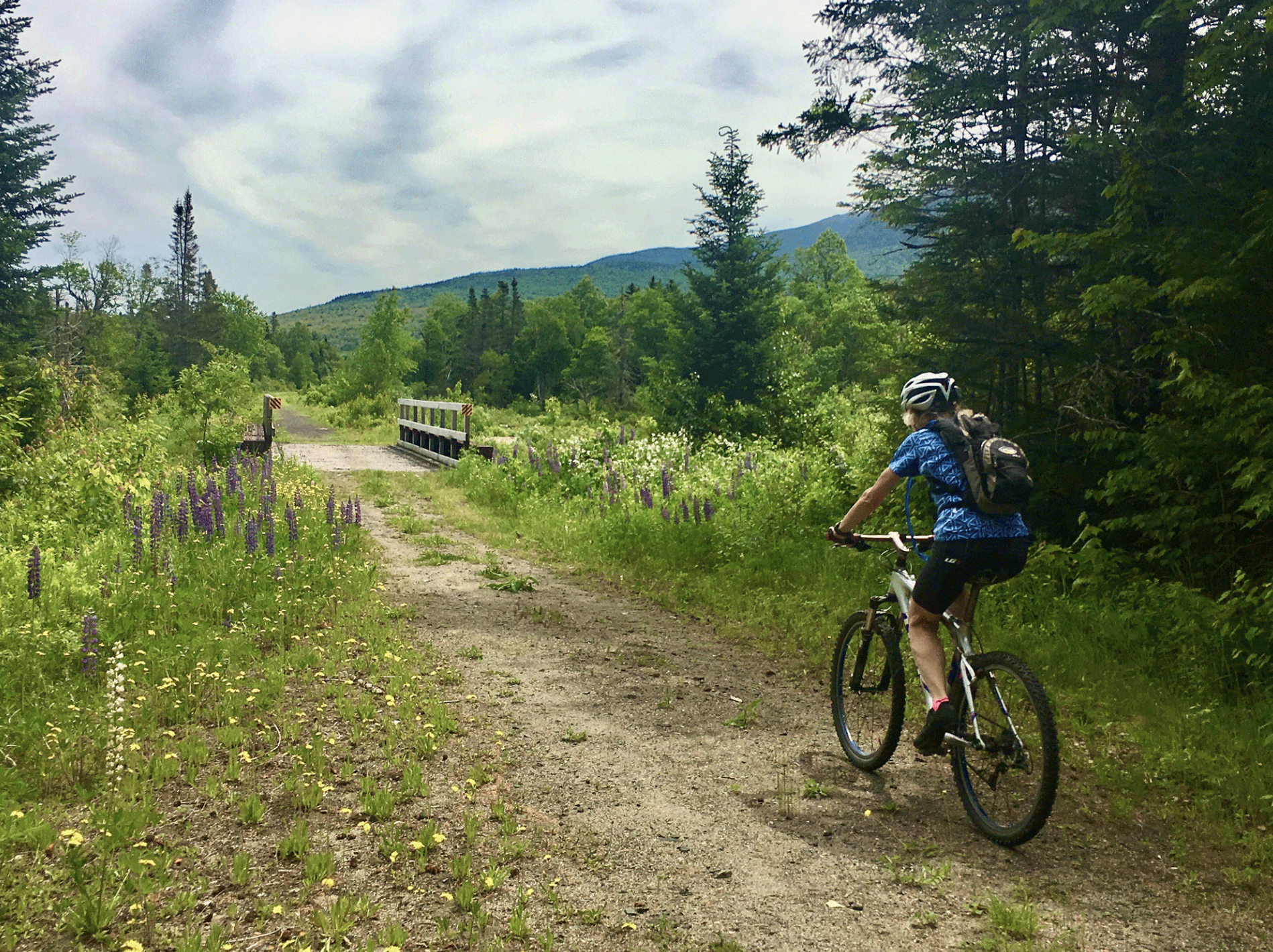
Rail trails, dirt roads, bike paths and quiet paved backroads have been linked together to produce a route across the state of New Hampshire.
​The route travels along river valleys and through the
​northern White Mountains Region of the state.

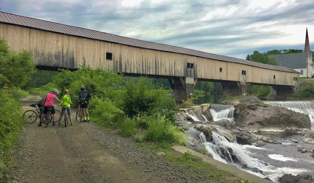
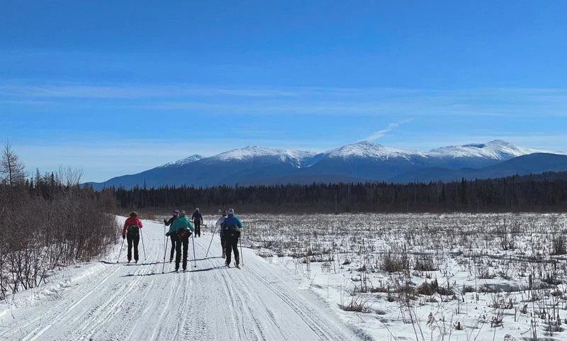
Bikers, Walkers, Runners, Skiers, Horseback Riders, Dog Walkers, Mushers...
All Enjoy the Trail!

Plan Your Trip

​NOTE: This route is NOT suitable or fun for bikes with skinny tires!
Got a Gravel Bike?? We Got Gravel!!


​Update on the Ammonoosuc Rail Trail:
This fall of 2023 there was a major grading project along 19 miles of the rail trail. The grading took care of big potholes, washboard and washouts, plus included restoring the drainage ditches to keep the water from big rainstorms flowing away from the trail rather than traveling right down the middle of it, eroding the trail as it goes. The grading was a great job well done.... BUT... the work exhumed the railroad ballast rock and big chunky gravel. This ballast and gravel was not rolled back down into the surface, it is being slowing pushed back in by the ATV use, so this fall there were many places on the trail that were more of an :adventure" than usual. The winter use of the trail and the spring will help fix this problem. The BEST assistance is to cover it up!  Hooray.. we are doing this!  In a unique collaboration with the NH Bureau of Trails, the Ammonoosuc Valley ATV Club and the Cross New Hampshire Adventure Trail, a hardpack surface is being applied to the trail. The ATV Club has received significant grant awards for this project, the xNHAT has paid the required match funding. The first test of the hardpack material was at the end of August 2022 in Lisbon behind the furniture factory. It has withstood the weather and ATV use for more than a year and more material was now applied in the fall of 2023 in areas near houses and businesses (amazingly.. there is NO DUST in this major hardpack mix!) plus in areas of constant issues with washouts.
​In the spring we will apply more hardpack surface material on more miles of trails and hope to cover most of the trail from Lisbon to Woodsville! ​This is an amazing accomplishment!
​The rail trail will be a gem not only due to the scenery, but due to a nice surface that is enjoyable for ALL of the allowed users!


Check the 
Trail Conditions Update page for updates.
Have you ever heard of a Story Map??
Take a Scroll through the
the xNHAT Story Map to learn about the ​Cross New Hampshire Adventure Trail 
     
Picture

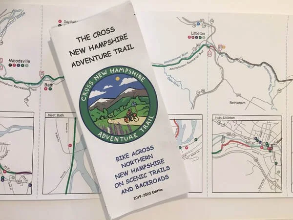
Do you like paper maps that you can use on the trail?​
Lots of xNHAT travelers like them, too!
​We have given away over 7000 maps over the past 3 years! For FREE!
We don't want cost to get in the way of having a beautiful map.


We have a NEW 2023-2024 EDITION of the 
7-Panel Waterproof Accordion Fold Map!


Send your mailing address to:  info@xnhat.org  
We will send you a map via the postal service!
You will get some stickers included, too.
​We work hard to get grant money to support the cartography, map printing, stickers and postage.
We gladly take a small donation to help our grant money go toward trail improvements instead of postage!

​We have appreciated the donations that have come in to support our maps, mailings and trail repair efforts!

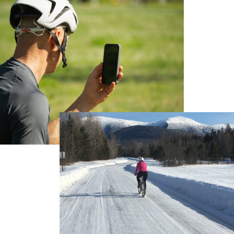
Not a "Paper Map Person"?
We know you are out there, so we have other options or you.
Download the route from RideWithGPS via our website to your smart phone or Garmin-like GPS device.
We have bought a special subscription from RideWithGPS so that anyone who downloads the route from our website will get all of the amenities of a full paying RideWithGPS membership. So, you don't need to be a paying member of RideWithGPS, just access the route via our website.


Go to the "Map"s page for more ways to navigate on the xNHAT:  Paper Maps and pdfs
For RideWithGPS route downloads go to: GPS Maps and Cue Sheets

Picture

Did you ride the route Border to Border? Did you ride any part of the route???
If you have traveled part of the route, however short, you get a Colorful Sticker!
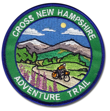
For completing every inch, End-to End, you deserve this
​Celebratory Colorful Highly Coveted Embroidered End-to-Ender Patch ...and a Sticker, too!

Send your mailing address to info@xnhat.org to get your awards!

Picture
Picture
Picture

​Our organization earned a 2023 "Gold Seal of Transparency" from GuideStar.
​GuideStar is a philanthropic research database of non-profits organizations. They review and provide accurate, up-to-date, unbiased information about non-profit organizations.
​We work to keep our accounts well organized and in good order. 
We are proud to have achieved their GOLD Status! 

Now for all that legal stuff:
Disclaimer: The Cross New Hampshire Adventure Trail and the authors of the website, social media and maps strive to prepare accurate information about the route and the conditions. However, they make no warranty, representation, or guaranty as to the accuracy of any information presented. Conditions on the route can change without warning due to weather, flooding, wear and tear, construction, tree falls, vehicles on the route, etc. You should verify the accuracy of all information obtained from this web site, wear a helmet and abide by safe bicycling standards. By using or relying on any material contained on this site, the user knowingly waives any and all claims for damages against any and all of the entities comprising the Cross New Hampshire Adventure Trail that may arise from the contained information.
Proudly powered by Weebly
  • Home
  • Maps
    • Paper Maps and pdfs
    • GPS Map Links and Cue Sheets
    • WINTER Route Border to Border
    • Day Trips on the xNHAT
    • Additional Rides Close to the xNHAT
    • Cross Vermont Trail
    • Story Map: "xNHAT, What's That?"
    • Interesting Info Links
  • Plan a Trip
    • Plan a Trip
    • Trail Conditions Update
    • What is the Surface Like?
    • What Bicycle to Ride?
    • What About Food?
    • Where to Stay?
    • Is There a Bike Shop?
    • What about Bike Rentals?
    • Parking: Day and Multi Day
    • Shuttle Services
  • DONATE
    • DONATE
    • More Ways to Support Us
  • North Country Welcomes Bicyclists
  • North Country Tri-Town Bike Friendly Initiative
  • Photos
    • Photo Tour of the Trail
    • Four Seasons on the Trail
  • News and Events
    • What's a Beaver Deceiver?
    • "Wheel Life" NH Magazine Cover Story August 2020
    • Israel River Bridge Restoration
    • Winter Explorations of the Rail Trails
  • Contact