In general, the rule on surface conditions is:
It Will Change
If it is bad, it will change,
If it is good, it will change.
Paved roads can be way worse than dirt roads,
Washboard happens. It will change.
Freshly graded roads are worse than the washboard.
Frost Heave Season happens, it will change into Mud Season.
A pothole filled with water is deeper than you think.
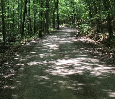
Riding a smooth dirt road in the woods is buttercream. Enjoy it while you have it,
It will change.
New asphalt pavement is sweet black velvet. Enjoy it while you have it, It will change.
The most challenging sections are on the western part of the trail: Some areas of the Ammonoosuc Rail Trail can be tedious, other sections are fine. We are working on improving these areas by using a hardpacked stonedust instead of big gravel in a few sections undergoing repairs in 2022. Yay!
Generally, if you have AT LEAST 32 mm tires, you will do OK in the gnarlier spots. The less experience you have in biking, the wider the tire you will enjoy.
If you are tired of the conditions on the rail trail or just want a change as you travel from Woodsville to Lisbon, use the alternate, road routes located on the west side of the river between Woodsville and Lisbon. They require climbing some hills with the reward of great downhills and pleasant views. Start off in Woodsville on on the alternate dirt and paved road route, it is hilly but rewarding. Or ride the rail trail to Bath, exit at the covered bridge and travel pleasant paved (hilly) backroads (West Bath Road to Pettyboro and Dodge Roads) on the eastern side of the river. Follow the map and cue sheets available on Ride With GPS, see the Maps section of this website.
As for the most challenging section on the Eastern portion of the trail:
1. In Gorham, the approximately 1.2 mile section after the Route 2 parking lot until you reach the entrance to Hogan Road allows ATV's. Just this section!
2. In the Halloween Storm of October 31, 2017, a one mile section of Hogan Road (Gorham to Shelburne) was overrun by the river. There are a few short sections that might need to be walked (by some of us!) because small river stones were exposed when the river washed out the roadway. The road washouts are occasionally repaired, but expect some adventure and walk-bike in a few places. Keep up with the Facebook posts and this section of the website for updates as they become available. It is a beautiful ride in the woods, worth some walk-bike. Don't do Route 2! No shoulder and fast moving traffic, BIG trucks and...a bad shoulder!
Of the 83 miles of the Cross New Hampshire Adventure Trail:
40.4 miles paved road
(only 10 miles on a primary road, 30 miles on quiet paved backroads)
11 miles dirt road
15.5 miles dirt rail trail, shared with ATVs
15 miles dirt rail trail, non-motorized only
1.1 miles paved recreation path
(only 10 miles on a primary road, 30 miles on quiet paved backroads)
11 miles dirt road
15.5 miles dirt rail trail, shared with ATVs
15 miles dirt rail trail, non-motorized only
1.1 miles paved recreation path
Contact Us:
Disclaimer: The Cross New Hampshire Adventure Trail and the authors of the website, social media and maps strive to prepare accurate information about the route and the conditions. However, they make no warranty, representation, or guaranty as to the accuracy of any information presented. Conditions on the route can change without warning due to weather, flooding, wear and tear, construction, tree falls, vehicles on the route, etc. You should verify the accuracy of all information obtained from this web site, wear a helmet and abide by safe bicycling standards. By using or relying on any material contained on this site, the user knowingly waives any and all claims for damages against any and all of the entities comprising the Cross New Hampshire Adventure Trail that may arise from the contained information.