Winter on the xNHAT!
It is possible to xc ski, snowshoe or winter hike all the way across New Hampshire from the Connecticut RIver to the Maine Border. The route travels from Woodsville all the way to Gorham on rail trails, abandoned rail lines and rail lines not used by trains in winter. Almost every mile is groomed by the local snowmobile clubs and the NH Bureau of Trails. One section of the route is an unplowed road (Hogan Road, from Gorham to North Road in Shelburne). This section is not used by snowmobiles, not groomed, so it is a backcountry experience. It may have deep snow or an icy crust, so you will need to know the conditions before heading out. There is a short walk on North Road to get to the AT trailhead on Route 2. From there you follow the AT for about 0.6 mile, then turn east on a snowmobile trail, which is NOT a rail trail, so it has hills, but is fun to ski when there are good conditions! Grooming by the snowmobile clubs occurs once or twice weekly, but in low snow or icy conditions, the trails may not be groomed and may be closed until adequate snow cover is obtained.
Current Winter Conditions:
January 14, 2023
NOT GOOD. Not a good snow year so far. Not even good enough for the rock skis. Walk with microspikes? Maybe. Fat bike? Probably ok, except for the places were the snow does not adequately cover the railroad ties (inactive rail corridor in winter). Just wait, it will get better. We all hope. Think Snow.
Stay tuned and when the snow comes the conditions report will be posted. The snowmobile clubs on the Ammonoosuc Rail Trail have not been able to ride it yet this season, the clubs on the Presidential were lucky to have good snow for a couple of weeks, but now they are not able to ride. Stay tuned, we will likely get a blizzard soon.
Note that there is a logging operation in Shelburne that has closed the snowmobile trail that is used by the Cross New Hampshire Adventure Trail to get from the western end of North Road (Hogan Road intersection) to the NH-ME border. So, this year, to get the winter Celebratory Embroidered xNHAT End-to-Ender Patch, all you need to do is cover the route between Woodsville and the eastern end of Hogan Road in Shelburne. You will be on rail corridor and Hogan Road ALL the way!!
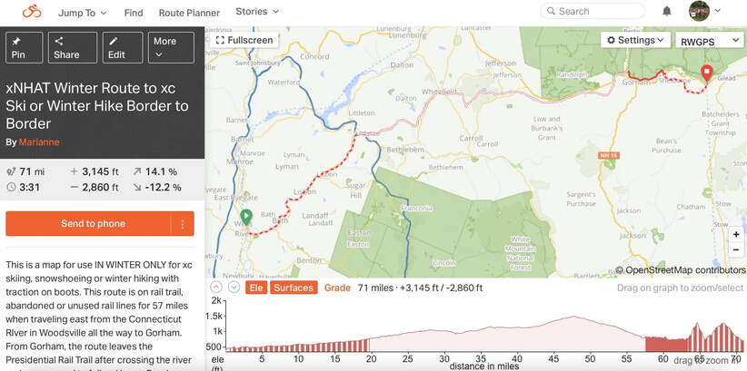
Here is the link to the RideWithGPS Map of the Border to Border Winter Route:
RideWithGPS Winter Route the xNHAT
KNOW the SNOW before you GO!!!
There is never a guarantee that the snowmobile clubs will groom the route on any particular day. Any snowmobile using the trails will provide some "grooming", but realize that that skiing on a snowmobile trail is NOT the same as skiing on a pristine corduroy trail at a cross country ski area. There are no "Tracks" for classic skis. The conditions may be perfect for skating, but they also can be NOT good! So, if you head out there, be aware of the snow conditions and realize that it is an ADVENTURE!! If you have questions, email us at [email protected]
ALSO: Share the trail with the snowmobiles... their club fees and registrations are paying for the grooming and winter maintenance of the trails. If you use the trails frequently, how about a donation to the local snowmobile club to show appreciation for their effort? They are very happy to take the "Thank You"!
Happy Trails and Think Snow!